
The phenomenon is not very common, but it does occur. Often this issue has to be resolved through the courts. For example, the most common case is the incorrect indication cadastral value. Accordingly, you have to file a claim and prove the mistake. But how to correctly correct the information in the cadastre through the court? What will it take? What features should a citizen pay attention to? Understanding all this is not as difficult as it seems. And going to court is not a very complicated process. The main thing is to find out all the nuances of this action in advance.
Error Definition
The first thing you need to do is find out what kind of error we are talking about. Does the situation being studied have any specific definition? Fortunately, it is available.
This is reproducible in cadastral document error, based on which cadastral register information about real estate was entered. What does it mean?
Everything is very simple. An error is recognized as a cadastral error if it occurred due to the data provided to Rosreestr. That is, when it was already displayed in the real estate information.
Correcting cadastral errors is not such a difficult matter. Especially if you properly prepare for the process. A citizen cannot make a cadastral error. But local governments - easily.
Who to complain about
Many people wonder who to complain to if a cadastral error is detected. Or more precisely, which authorities should be sued. There are several options to solve the problem. Among them are:
- a claim against an authority that made a mistake when providing information about real estate;
- submitting an application to Rosreestr.
It is usually possible to avoid litigation. But it also happens that for one reason or another, citizens are denied changes to the law. Accordingly, then the dispute cannot be resolved peacefully. And we have to correct the cadastral error in judicial procedure.
Who is the best person to sue? Many point out that it all depends on the situation. If Rosreestr has not refused to correct it, there is no need to rush into legal action. And as soon as a citizen has received a written refusal, it is better to complain to the cadastral chamber. After all, the authorities issuing certain documents can only issue papers with changed data. But if Rosreestr refused to change the data, only going to court against this service will help. 
Grounds
What are the grounds for correcting a cadastral error? There are not as many options as it seems. In general, there are several reasons why changes can be made to the cadastre. These are precisely the grounds for correcting any errors:
- An application from the owner submitted to Rosreestr requesting changes. Good way peaceful settlement of the issue.
- Independent decision of the relevant authorities. A rare phenomenon that practically never occurs in practice.
- A court decision issued after a citizen applied with documents confirming erroneous data in cadastral passport.
Most often, they try to correct cadastral and technical errors in the real estate passport without a court hearing. But this doesn’t always work out. The grounds for going to court may include:
- documents indicating refusal cadastral chamber in registering real estate due to errors;
- written refusals from Rosreestr to make changes to documents in which certain errors were revealed;
- the presence of any certificates confirming errors in the cadastre and inaction of the cadastral chamber.
It is necessary to prepare for going to court. After all, no one will satisfy the claim just like that. What can be done before correcting a cadastral error (or technical) in court?
Expertise
The first step is to conduct an independent examination. She will have to confirm the presence of certain errors in the cadastral passport, as well as display new, correct data. 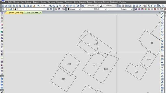
Correction of cadastral error in location land plot Engineers will help. It is required to carry out geodetic work and land surveying. They will obtain information that will be useful in court. Namely, new, correct data.
You can also call an appraiser who can estimate the real cadastral value of the property. This is necessary in order to prove incorrect prices in the apartment or land passport.
Only after an independent examination does it make sense to go to court. Otherwise, you won’t be able to prove that you’re right. This means that the claim will not be satisfied. Therefore, you will have to prepare for the court hearing.
Contact Rosreestr
Further, if it is necessary to correct a cadastral error in the location of a plot or any other data, the citizen must contact the cadastral chamber or Rosreestr. There he brings:
- passport;
- real estate cadastral passport with errors;
- documents that confirm erroneous data and point to new information;
- application of the established form for making changes;
- receipt of payment of state duty (in the amount of 350 rubles).
Within a month, Rosreestr must replace the data. Or the citizen will receive a written notification refusing to make changes. This will allow him to go to court.
IN Lately Correcting cadastral errors in the relevant passports is commonplace. You can also contact the judicial authorities when Rosreestr does not take any action at all. When submitting an application, a citizen will be given a receipt indicating the processing time for the application. If the cadastral chamber is silent, you can not only indicate the correction of errors in the cadastre in a lawsuit, but also the inaction of the relevant authorities. 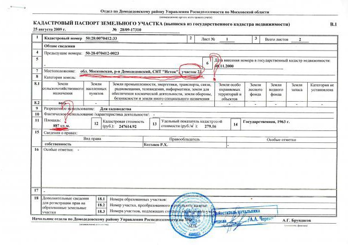
Deadlines
Next important point- these are the deadlines for contacting the relevant authorities. The thing is that it is not always possible to go to court. Therefore, you have to worry in advance about meeting the deadlines established by law.
The limitation period for documents is 3 years. It is advisable to keep within this period. And even better, immediately after discovering a cadastral error. The faster the better.
Correcting cadastral errors also has its limitations. To make changes to the application, 30 days are usually allotted; if it is a technical error in the cadastre, 5 days. A month is given for the execution of the court decision.
Accordingly, the sooner a citizen goes to court, the better. The statement of claim must be considered no more than 5 days from the date of receipt. But the question of scheduling a court hearing may drag on. The court itself sets the date for the hearing. 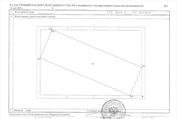
Collection of documents
Correcting a cadastral error in court is not a rare occurrence. And, as has already been said, you will need to prepare for it to one degree or another. The main problem is collecting everyone necessary documents. After all, only if they exist will the application be considered by the court. What will be useful to the owner of a premises or real estate? What documents should he bring? In order to file a claim to correct a cadastral error in the location of a plot or any other point, you should:
- ID card (passport);
- documents on ownership of a particular property;
- cadastral passport with errors;
- documents indicating the presence of errors, as well as new information;
- refusal to correct a cadastral error from the relevant authorities;
- an extract that was given when submitting an application to Rosreestr (need in case of inaction of the body).
It would seem nothing special. But in fact, the main problem becomes obtaining new data. More precisely, it is difficult to prove errors of certain types and appeal against them. If all the evidence is available, there is no need to worry - the court will definitely side with the plaintiff. What does judicial practice show? Correction of a cadastral error is a process that is extremely rarely satisfied in favor of the defendant. Most often, the relevant authorities are forced to make changes to cadastral passports.
Court hearing
What happens in court? Everything is very simple - the relevant authorities will study all the documents provided. And if at the meeting it turns out that errors were actually made in the primary cadastral passport, the cadastral chamber will be forced to make changes in accordance with reality.
The period for correcting a cadastral error, as already mentioned, is 30 days. Accordingly, it is at this time that the information in Rosreestr is changed. The countdown will begin from the moment the court decision is made. 
It happens that the court sides with the defendant. These are very rare situations. Then the cadastral passport is recognized as valid, no replacements are made. However, a counterclaim may be filed against the plaintiff - for compensation for moral damage. But this is also far from the most common practice.
Rules for writing a claim
Correcting a cadastral error in the location of a plot or any other information about real estate is not that difficult. Many people are interested in how to properly file a claim. When all the documents have been collected, you will have to draw up an application according to a certain principle. And then take the full package of papers to the civil court. It is necessary to contact the authority at the location of the property that caused the dispute.
What information must be included in the claim? Much depends on the situation. That is, it depends on what information needs to be changed. Thus, the claim usually writes:
- the name of the authority to which the plaintiff applies;
- personal data and contacts of the applicant;
- information about the property;
- information about engineers who made mistakes (for example, when determining the location of a site);
- new information that needs to be entered (with confirmation).
All this is recorded in the claim, then filed in the appropriate court. But how to correctly write a statement of claim to correct a cadastral error? The sample of this document cannot be called template. But one example will help to draw up a correct appeal to the court.
Sample
How to properly file a lawsuit to correct the data in the cadastral passport? It's not that hard to do. The main thing is to have cadastral data, as well as real information about real estate. Then it will be much easier to correct the cadastral error in court. Practice shows that an incorrect claim is a basis for refusing changes. Therefore, you must draft your application correctly. It might look like this:
An application to recognize the information included in the real estate cadastral passport as invalid and to make changes to it in accordance with real data.
I, Ivanov Ivan Ivanovich, born on August 15, 1965, am the owner of a land plot located at the address: Moscow region, village of Petrishcheva, st. Khmelnitsky 15, I ask you to make changes to the cadastral passport of the land plot due to incorrect data on the location and incorrect cadastral value.
On May 20, 2001, Vasily Petrovich Petrov carried out surveying and geodetic work on my site. He provided a drawing of the property which indicated the location of the site was incorrect. On May 22 of the same year, the property due to me was assessed. It turned out to be much higher than it actually was. 
On July 8, 2001, I, Ivan Ivanovich Ivanov, conducted an independent examination. She showed that the cadastral value was indeed inflated, and the drawing was drawn up with an error. The results of the experts' work are attached to this claim.
On August 20, 2001, I contacted Rosreestr to make changes in accordance with the data received from the results of an independent examination. I was refused. A written refusal to make changes is attached.
Based on all of the above, I ask that cadastral errors and technical inaccuracies be corrected in court. I attach the original cadastral passport to this statement of claim.
After the trial
So, the trial is over. What's next? Immediately after the relevant decision is made, the plaintiff must again deal with paperwork. Correction of cadastral errors is possible after re-applying to Rosreestr. You will need to bring identification documents and a court decision.
Further, as already mentioned, the cadastral chamber will have to make changes to the real estate passport and issue it to the owner. All this is given 30 days. And if we are talking about a technical error - 5 days. Refusal will no longer take place.
That's all. The judicial appeal process has been fully completed. On average it takes about six months. Therefore, one should not think that it is possible to correct the data of the cadastral passport in the shortest possible time in court.
Cadastral errors lead to the appearance of incorrect and inaccurate information in the state register. This can lead to various difficulties in the future. Elimination of cadastral errors is carried out depending on the cause and nature of the inaccuracy. It is imperative to carry out this procedure so that future transactions can be carried out without complications.
Concept
A cadastral error is an inaccuracy in the state real estate register. According to modern legislation, there are 2 types of errors:
- technical;
- cadastral.
The definition of cadastral error is specified in Federal Law No. 218 "On state registration real estate", which began to operate on January 2, 2017. This is the unreliability of the information indicated by the specialist. But in comparison with the cadastral error, it appears not through the fault of the employee, but due to the presence of inaccuracies in the documentation provided for registration. The essence of the cadastral error comes down to: that the property documentation will contain inaccurate information that needs to be corrected.
Usually they are allowed by engineers preparing official papers to carry out registration of land allotments, or by government agencies who incorrectly designated the location diagram, category of the site, draft boundaries, and address. Errors appear due to inaccuracy in measuring angles, calculating area, and coordinate parameters.
Causes
A cadastral error appears for the following reasons:
- Engineers use old equipment and carry out land surveying in conventional or local coordinate systems without taking into account national rules.
- The specialist does not go to the area, indicating approximate parameters in the plan. To substantiate the information, cartographic materials and information about adjacent plots of land registered in the state register are used.
- Not all employees have sufficient qualifications to perform the work: preparing equipment and processing indicators.
- Not all activities are carried out carefully.
For these reasons, there may be calculation errors and inaccuracies. All this is recorded in the documentation. Municipal authorities also make mistakes during inventory work, preparing draft land boundaries for implementation cadastral activities. All types of inaccuracies must be corrected so that there are no future problems regarding the disposal and ownership of property.
Technical error correction
Such inaccuracies are corrected by cadastral authorities. This will require archival information, which will be used to verify the coordinates against the information recorded in the cadastral passport. Technical inaccuracies are removed by decision of the authority cadastral registration, published when available. Other persons who must submit an application can also initiate the procedure. This is also carried out by court order.
If there are technical errors, it is not necessary to go to court. Rosreestr employees who keep records will check and eliminate inaccuracies. Only in exceptional cases, when cadastral institutions refuse to carry out the correction, can the interested person go to court. Technical inaccuracies are eliminated within 5 days after detection. At the same time, a refusal to correct is issued.
Correction of cadastral inaccuracies
A cadastral error is eliminated according to the standards specified in the law. If the primary source of identification of inaccuracies was the boundary plan, they are eliminated through information interaction or by a court decision, which indicates the need for adjustments.

So, there are 2 options:
- administrative path;
- judicial decision of the issue.
Each owner may notify any inaccuracies. To do this, he needs to personally contact the state cadastre or via the Internet by sending an application using State Services.
If incorrect information is detected by the cadastre authority, a decision is made to correct it. The decision includes the date of detection, description with justification. The state cadastre documentation also indicates the need to correct information. Recognition of a cadastral error occurs by reconciling the data in the documentation. Then the organization maintaining cadastral records sends the decision to interested parties to correct the data. After 6 months, the information is entered into the database of the all-Russian state real estate cadastre.
Administrative procedure
Often a cadastral error is associated with a discrepancy between the boundaries of a land plot and the parameters recorded during land surveying. This is usually revealed when carrying out the same procedure for neighboring land ownership. The cadastral specialist who draws up the boundary plan receives the coordinates of the boundaries, and then finds out that there is a discrepancy in the data. If a cadastral error is detected, what to do in this case? Typically, in such situations, the engineer contacts the copyright owner to correct the errors.
The copyright holder whose boundary plan contains inaccurate data can contact the land management company that made the inaccuracies. If its employees refuse to correct the information, you can go to court. Based on the letter from the Ministry of Economic Development of 2009, information can be corrected by any engineer conducting land surveying.
The current boundary plan is submitted to the state cadastre, and on its basis the site is registered, and the boundaries of neighboring territories change. If adjacent lands are registered after this, then statements from neighbors are required to correct the boundaries.
Going to court
If cadastral practice is discovered, it shows that in this way it will be possible to quickly correct inaccuracies in the documentation. The tasks of this body are to prove the presence of incorrect information and agree on options for its removal by the parties.
Grounds for going to court:
- refusal of the institution that carried out the elimination of inaccuracies;
- refusal of the state cadastre to correct data at the request of the property rights holder;
- an engineer's conclusion about an error discovered during site surveying.
In judicial practice, there have been many cases regarding the need to enter reliable information. To do this, a number of documents are verified. Going to court is usually required in cases where the owner is denied the procedure for changing data. After correcting the information, it will be easier to conclude various real estate transactions that were previously impossible to complete.
Error detection
Identification of inaccurate data occurs:
- cadastral service;
- owner, user;
- other interested parties, for example the owner of a neighboring plot.

Typically, incorrect data appears during:
- registration of real estate;
- entering data into the cadastre;
- deregistration of real estate;
- obtaining a passport or extract from the cadastre;
- familiarization with the tax alert;
- contacting the owner to resolve property issues;
- receiving a notification from the cadastre about data inaccuracy.
There are situations when the owner of a neighboring territory carries out land surveying and registration of his property. As a result, the boundaries of the site are shifted, and therefore changes are made without notification. This happens if the land was registered before March 1, 2008 according to the old standards. Therefore, the owners of these objects need to carry out land surveying and establish site parameters according to new standards.
Why do you need to correct errors?
Incorrect data can lead to the following consequences:
- it will not be possible to register the object, make changes or deregister;
- difficulties with registration of property rights to an object;
- taxes and state duties are levied at a high rate;
- restrictions on the use of real estate;
- difficulties in issuing loans, benefits, subsidies;
- disputes between owners of neighboring plots;
- difficulties with the disposal of real estate.

The property owner is most interested in correcting the data. Therefore, it is important for him to independently take the initiative to correct information. The cadastre may correct inaccuracies after inspections or if inaccurate data is found from any sources.
Why do the owners not agree with the correction of inaccuracies?
There are often situations when a property owner, when finding inaccurate data, does not want to correct it. This is due to the fact that such information is beneficial. For example, after revaluation it was assigned to the wrong category of land. Because of this, underestimated standards were included in the calculation of the cadastral value.

Then the tax burden for the owner of the site is noticeably reduced. If any transactions are carried out with the object that were declared illegal, the owner suffers losses. For example, a house was built on a plot of land, but after discovering an oversight, it turned out that the object is located on the border with a neighbor’s plot without retreat. And the neighbor will demand that the errors be corrected. Therefore, in order to avoid many difficulties, it is necessary to correct incorrect information immediately after it is discovered.
Cadastral errors cause the appearance of incorrect and inaccurate information in state cadastre. The features and procedure for correcting such errors depend on the cause and nature of the inaccuracy itself.
First of all, a technical error may occur, which includes all kinds of clerical errors, typos, arithmetic or grammatical incorrectness, or similar errors made by the Russian state cadastre authorities when maintaining information GKN bases and leading to a discrepancy between the data entered into the all-Russian register and the information in the documentation that served as the direct basis for entering the relevant information into the cadastral data.
As a rule, such inaccuracies in the State Property Code do not cause serious obstacles to the implementation by copyright holders real estate their rights.
The next type of error in the state cadastre is incorrect data that arose, according to paragraph 2 of part 1 of Article 28 of the law on the real estate cadastre, when an error from the documentation that served as the basis for entering information into the State Property Committee was reproduced in the national cadastre database (cadastral error in information).
Causes of cadastral errors
A technical error occurs when state cadastre employees incorrectly enter information from original documentary sources. In the case of errors, there may be several reasons. In the vast majority of situations, they are associated with errors by cadastral engineers drawing up the boundary plan.
Today, in practice, most often a cadastre error is discovered that is associated with a discrepancy between the coordinates of land boundaries established by the cadastral engineer and their actual location. The discrepancy usually occurs because:
- many cadastral engineers those carrying out land management work use outdated equipment and carry out land surveying in conventional or local coordinate systems without taking into account the national system;
- some cadastral engineers for some reason do not go to the area, recording cadastral plan only approximate coordinates of the earth. To substantiate these data they use cartographic materials and information about adjacent plots of land previously registered with the State Property Committee;
- not all cadastral engineers have sufficient qualifications to correctly prepare equipment and correctly further process the measurements taken;
- Not all land surveying work is carried out carefully. Because of this, miscalculations in calculations, errors in the fencing configuration determined by the engineer, and other inaccurate information in the documentation may occur.
Cadastral errors are quite often made by municipal authorities when carrying out inventory work, preparing draft boundaries of plots for cadastral work or other acts that change some specifications real estate objects.
Technical error correction
Technical errors in the State Property Committee, when they are detected, as a rule, are corrected easily and quickly by the cadastral authorities themselves. To do this, the corresponding survey file is retrieved from the archival data and the coordinates indicated in it are compared with the information entered in the object.
Technical inaccuracies are eliminated based on the decision of the cadastral registration body, which is issued when errors are detected by employees of the body itself or other persons. In the latter case, the basis for checking and further correcting errors is the corresponding statement of a person interested in eliminating inaccuracies, or a court decision that has entered into force regarding the correction of such an error.
Usually, in practice, if technical inaccuracies are discovered in cadastral data, there is no need for judicial resolution of the case. Rosreestr employees responsible for maintaining the State Property Committee conduct an inspection and eliminate all identified inaccuracies as soon as they are discovered. And only in rare situations, when the cadastral authorities for some reason refuse to correct an error identified in the Civil Code, is it advisable for the interested party to seek its elimination through legal proceedings.
A technical error in the information of the Russian State Property Committee must be corrected within a five-day period after it has been identified by the cadastral authority or a statement from an interested person or a court decision has been submitted to the state cadastral body.
Within the same period, a refusal by the state cadastral body to correct the error specified in the application must be drawn up.
Correction of cadastral errors in information
As stated in the law regulating the fundamentals of legal relations in the field of real estate (Part 4 of Article 28), such errors are eliminated in the manner established by the legislator to take into account changes in the relevant real estate. When the primary source of an identified error in the Civil Code is a boundary plan, the error will be eliminated either through information interaction or on the basis of a court decision indicating the need to correct such an error.
So, to eliminate incorrect data, the legislator allows 2 ways:
- Administrative path;
- Resolution of the issue through legal proceedings.
Today, any property owner can report a cadastral error found either in person when contacting a department of the state cadastral body, or by sending a corresponding application on the government services portal.
If a cadastral inaccuracy is identified by the cadastral registration authority, an appropriate decision is made on the need to eliminate the detected error. The decision shall indicate the date the errors were discovered, their description with a specific justification for why the relevant information is erroneous. The document from the state cadastral authorities that identified errors also contains an indication of the need to correct the found error.
The body conducting cadastral registration sends decision interested parties or authorized bodies to correct identified inaccuracies in the information.
At the end of the six-month period after sending to the copyright holder of the relevant property a decision on the need to correct cadastral errors in the information data of the State Property Committee on the location of the boundaries of a plot of land, employees of the body conducting cadastral registration have the right to enter changes into the information base of the all-Russian state real estate cadastre about the correct location of the boundaries and, accordingly, the area such a plot of land and without the consent of the landowner.
Correcting errors in information administratively
As already mentioned, the most common cadastral error is the discrepancy between the real boundaries of a plot of land and the boundaries established in the land surveying procedure. Typically, such a cadastral error is discovered during land surveying of a neighboring plot of land.
A cadastral engineer drawing up a boundary plan for a neighbor receives certain border coordinates and then finds out that they do not correspond to the data already indicated in the state real estate cadastre regarding the adjacent plot. Usually in such situations, the cadastral engineer carrying out boundary work at a neighbor (or the neighbor himself) turns to the legal owner of the corresponding adjacent land with a proposal to correct the error in the location of his plot.
The owner of a plot whose boundary plan contains erroneous data can contact the land management company that carried out the survey and made the mistake. If the organization that performed the work refuses to correct the incorrectness free of charge, you can go to court.
According to a letter from the Ministry of Economic Development of 2009, any cadastral engineer carrying out land surveying has the right to correct mistakes. Accordingly, in a situation where, when determining the boundaries of the land, it turned out that they intersect neighboring lands, the engineer enters new, correct coordinates of the boundaries into his previous boundary plan.
But there is a certain nuance here too. Thus, if neighboring plots of land with which the territory crossed were registered in the State Property Committee before 03/01/2008, there will be no need to agree with their landowners on new boundaries changed in the boundary plan. The adjusted boundary plan is submitted to the Russian state cadastre body, and on its basis the corresponding site is registered, and the boundaries of neighboring territories also change accordingly.
If adjacent plots of land were registered with the State Property Committee after the above date, in order to correct the boundaries it will be necessary to receive written applications to correct the error and submit title documentation for the land from all neighbors of the adjacent lands whose boundaries were affected.
Going to court
The objectives of legal proceedings when correcting cadastral errors are to prove the presence of incorrectness in the cadastre and (or) agreement by the parties on ways to eliminate it.
Grounds for legal proceedings in cases of correction of cadastral errors:
- refusal of the body performing cadastral registration to carry out land registration due to identified cadastral inaccuracy;
- refusal of the state cadastre body to correct an error at the request of the property owner;
- conclusion of a cadastral engineer about a cadastral error found during land surveying of the corresponding plot or neighboring lands.
In what cases can you challenge a deed of gift for an apartment?
Social mortgage for a young family
Information about land plots that are in the real estate cadastre may be inaccurate or incorrect.
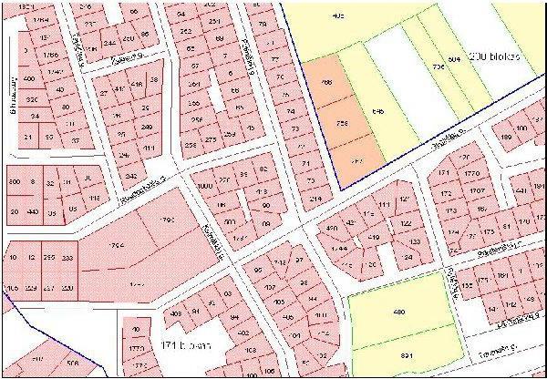
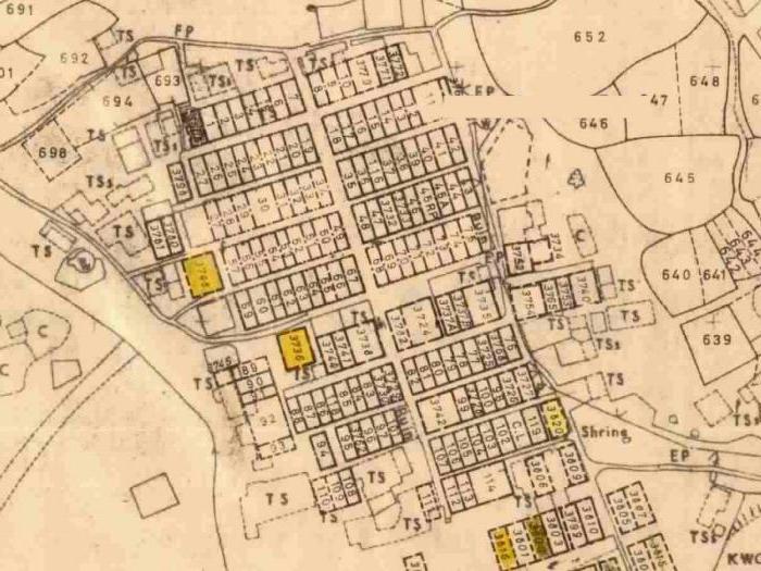
Entire arrays land plots may have the wrong location⇑
These errors, whether incorrect location or incorrect land title address, should be corrected to avoid further problems with the use and disposition of the site. Ordering a boundary plan to correct a cadastral error would be the right decision.
This article is devoted to cadastral errors that accompany cadastral activities. Who is responsible for their appearance and what needs to be done to eliminate them.
What are the mistakes in the real estate cadastre and who makes them?
Errors in cadastral information They can also be of a fairly harmless nature - such as typos, omission of some minor information, etc. And they can be a serious violation of the reliability of information about your site.
They come in two types - cadastral and . A separate article has been written about technical ones. We will focus on cadastral errors.
Cadastral error appears when providing incorrect information about the land plot when registering (or making changes to) the border. That is, this is incorrect information about the location or configuration of the storage device.
Such errors can be made by municipal authorities (authorized to issue) or by judges who made a court decision with incorrect data about the site. Ultimately, the cadastral engineer issues the boundary plan, but the error may be based on incorrect “initial” data on which he relies (land plot diagram and court decision). Therefore, do not rush to blame him; first you need to understand the reasons.
Who corrects them and how?
Accordingly, the errors are corrected by the body or person who made them. Read about the technical error. The procedure for correcting cadastral errors is given below.
In order to fix cadastral error the owner needs either:
— contact a cadastral engineer to prepare a boundary plan to correct the cadastral error and clarify the boundaries of the owner and his neighbors. There is a nuance here - if your neighbors put their plots on the cadastre before 03/01/2008, then the cadastral engineer will correct both your plot and theirs in the boundary plan. If after, then only in agreement with the neighbors. If there are no disagreements with neighbors (an agreement is signed) and representatives of Rosreestr agree with the change in the boundaries of land users, then the error will be eliminated pre-trial.
- contact with statement of claim to court if the error could not be eliminated by other means.
The defendant can be either the cadastral chamber and the cadastral engineer (who made a mistake), or the owner of the land plot whose borders cross yours. The purpose of the claims is to make changes to the erroneous location of the boundaries namely Your his land plot, since you cannot demand to change information about the land plot of another owner. But again, after the court’s decision, it will be necessary, on the basis of this decision, to order the preparation of a boundary plan to correct the cadastral error. Do not forget that only cadastral engineers, and not the court, have the right to make changes to the real estate cadastre.
How to identify a cadastral error on your land plot?
Reveal cadastral error it's not that simple. Let us remind you that a cadastral error can only affect land plots included in cadastral registration. Below are options for detecting a cadastral error, that is, an error in the location of your site.
The easiest way is to find your site on. Gross inaccuracy will be visible to the naked eye in the photograph.
It is more difficult and more expensive to call a cadastral engineer and check the compliance of the actual and cadastral boundaries. This is the so-called. But it’s worth doing if for some reason you doubt your limits and you need accurate measurements. After all, this procedure is not cheap. If the boundaries of your land plot do not correspond to the cadastre, it means an error has crept in or a neighbor has slowly moved the fence in the winter (and this has happened in our practice).
Most often, you do not even suspect that the cadastral information about your plot is incorrect. Your neighbor will notify you about this if he registers the plot later than you and asks you to agree on the border and correct the cadastral error.
Deadlines for correcting cadastral errors
It is difficult to name a specific time, because in order to correct them, it is necessary either to prepare a boundary plan (in case of a peaceful solution) or prepare a land management examination (in case of a judicial decision). Accordingly, to the time frame for Rosreestr’s consideration of an application to correct an error, it is necessary to add time for preparing an interplan or conducting judicial activities. On average, a boundary plan is prepared in 2 weeks or less, and the trial can last for several years.
The cadastral chamber (upon submission of all documents) must make a decision to correct a cadastral error within 18 working days or 30 working days (if it is necessary to receive additional information from other departments in the order of information interaction).
An example of drawing up a boundary plan to correct a cadastral error
To understand what a boundary plan looks like and what is included in it, we provide a sample. Of course, the appearance and filling will change somewhat, especially in . After all, a cadastral error can be of various kinds, and its description is included in the conclusion. Unfortunately, the legislative bodies cannot find the “correct” type of boundary plan in their opinion and are churning out orders and additions to orders, resolutions and various versions of laws. This leads to the fact that “yesterday’s” view and filling of the interplane “today” is no longer relevant. The essence of the document, in principle, has not changed since the time of “land management”. At this point, the boundary plan should look like the one on the slider on the left ⇐ . We'll keep you posted on what it will look like afterwards.It is worth adding that recently boundary plans have been submitted to the Rosreestr authority in electronic form, and in an encrypted XML file. And the customer does not even have the opportunity to familiarize himself with the paper version of what he has to give to the cadastral chamber. Therefore, we recommend that you ask the cadastral engineer for a paper version of the interplan, although this is not required by state accounting authorities.
Cost of drawing up a boundary plan to correct a cadastral error
Prices again depend on the need for field measurements. In some cases, you can do without a field survey. Without visiting the site, the cost will be 30% cheaper. But it should be understood that preparing a boundary plan may not solve the problem in case of disagreements with representatives of the cadastral chamber. In this case, you will be subject to legal costs.
A cadastral error can become a headache for the owner of a plot, as it can interfere with the disposal of real estate. You won’t be able to fix it yourself; you need to entrust this work to professionals. has been operating in the geodetic services market since 2000. Our cadastral engineers were among the first to receive and have proven themselves well in cadastral activities. Contact our company - and you will not regret it! We will prepare a boundary plan to correct the cadastral error and put in order the cadastral information about your land plot.