font size
ORDER of the Ministry of Regional Development of the Russian Federation dated 12/28/2010 820 ON APPROVAL OF THE CODE OF RULES SNIP 2-07-01-89 URBAN PLANNING - LAYING AND DEVELOPMENT ... Relevant in 2017
5. Residential areas
5.1. Residential areas must be provided in order to create a comfortable, healthy and safe living environment for the population. Objects and activities that are incompatible with the requirements of these standards are not allowed to be placed in residential areas.
Residential buildings are located in residential areas different types(multi-apartment multi-storey, medium and low-rise; blocked; manor houses with apartment and personal plots); detached, built-in or attached objects of social and cultural services for the population, taking into account the requirements of section 10 of these standards; garages and parking lots for cars owned by citizens; cult objects.
It is allowed to place separate public, business and communal facilities with a plot area, as a rule, not more than 0.5 hectares, as well as mini-productions that do not have a harmful effect on environment(including noise, vibration, magnetic fields, radiation impact, pollution of soil, air, water and other harmful effects), outside the established boundaries of the sites of these objects. Size sanitary protection zones for objects that are not a source of environmental pollution, it should be at least 25 m.
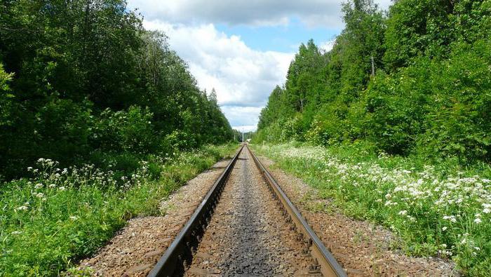
Note. Residential areas also include territories of garden and dacha development located within the boundaries (line) of settlements. The development of social, transport and engineering infrastructure in relation to these zones must be provided in volumes that provide the possibility of permanent residence in the future.
5.2. The planning structure of residential areas should be formed in conjunction with the zoning and planning structure of the settlement as a whole, taking into account urban planning and natural features territory. At the same time, it is necessary to provide for the interconnected placement of residential buildings, public buildings and structures, the road network, landscaped areas for common use, as well as other objects, the placement of which is allowed on the territory of residential areas according to sanitary and hygienic standards and safety requirements.
5.3. For a preliminary determination of the general size of residential areas, it is allowed to take aggregated indicators per 1000 people: in cities - with an average number of storeys of residential buildings up to 3 floors - 10 hectares for buildings without land plots and 20 hectares - for development with a plot; from 4 to 8 floors - 8 hectares; 9 floors and above - 7 hectares; in rural settlements with predominantly manor buildings - 40 hectares.
For areas north of 58° N, as well as climatic subregions IA, IB, IG, ID and IIA (SNiP 23-01), these indicators may be reduced, but not more than 30%.
When determining the size of the territory of residential zones, one should proceed from the need for a phased implementation of the housing program. The volume of the housing stock and its structure are determined on the basis of an analysis of actual and forecast data on the family composition of the population, its income levels, existing and prospective housing provision, based on the need to provide each family with a separate apartment or house. For state and municipal housing stock - taking into account the social norm of housing area established in accordance with the law Russian Federation and regulatory legal acts of the subjects of the Russian Federation.
Note. Aggregated indicators are given with an average estimated housing supply of 20 m2 / person.
Estimated standards for housing provision may be specified in regional urban planning standards.
5.4. The territories of the residential zone are organized in the form of the following functional and planning residential formations:
Quarter (microdistrict) - the main planning element of development within the boundaries of the red lines or other boundaries, the size of the territory of which, as a rule, is from 5 to 60 hectares. In a quarter (microdistrict), land plots of residential development may be allocated for individual houses (households) or groups of residential buildings in accordance with the land surveying plan;
District - is formed as a group of quarters (neighborhoods), as a rule, within the territory bounded by city highways, lines railways, natural boundaries (river, forest, etc.). The area of the district should not exceed 250 hectares.
Notes. 1. District, quarter (microdistrict) are objects of territorial planning documents and documents on territory planning.
2. When developing documents on planning the territory for a separate section of the territory, occupying part of the territory of a quarter or microdistrict, it is necessary to ensure the compatibility of the objects to be placed with the surrounding buildings and the required level of social and cultural services for the population for the quarter (microdistrict) as a whole.
3. In blocks and microdistricts of residential zones, it is not allowed to place objects of urban significance, as well as to arrange transit passages on the territory of groups of residential buildings united by a common space (courtyard). The territory of groups of residential buildings, as a rule, should not exceed 5 hectares.
5.5. When planning the organization of residential zones, their differentiation should be provided for by types of building, its number of storeys and density, location, taking into account historical, cultural, natural, climatic and other local features. The type and number of storeys of residential development are determined in accordance with socio-demographic, national-domestic, architectural-compositional, sanitary-hygienic and other requirements for the formation of a residential environment, as well as the possibility of developing social, transport and engineering infrastructures and ensuring fire safety.
Residential areas may include:
Building zone with multi-storey residential buildings (9 floors or more);
development area with mid-rise residential buildings (from 5 to 8 floors, including attic);
Development area for low-rise multi-apartment residential buildings (up to 4 floors, including the attic);
development area with blocked residential buildings;
development zone with individual detached residential houses with personal plots of land.
In the districts compact living small nationalities, when forming residential areas and choosing the type of dwellings, it is necessary to take into account the historically established way of life of the population.
Note. In regional and local urban planning regulations, rules for land use and development, and in their absence, in urban planning documentation, it is allowed to clarify the typology of residential development, as well as provide for additional restrictions on the placement of individual objects in residential development zones.
5.6. Estimated indicators of the volumes and types of residential development should be made taking into account the current and projected socio-demographic situation and incomes of the population. At the same time, it is recommended to provide for various types of residential buildings, differentiated by the level of comfort in accordance with Table 2. The average calculated indicator of housing provision depends on the ratio of residential buildings and apartments of different comfort levels and is determined by calculation.
table 2
The structure of the housing stock, differentiated by the level of comfort
| Type of residential building and apartment by level of comfort | Norm of the area of a residential building and apartment per person, m2 | The formula for settling a residential building and an apartment | Share in total housing construction, % |
| Prestigious (business class) | 40 | k = n + 1 k = n + 2 | 10 --- 15 |
| Mass (economy class) | 30 | k = n k = n + 1 | 25 --- 50 |
| Social (public housing) | 20 | k = n - 1 k = n | 60 --- 30 |
| Specialized | - | k = n - 2 k = n - 1 | 7 --- 5 |
| Notes. 1. Total number living rooms in an apartment or house k and the number of people living n. | |||
| 2. Specialized types of housing - hotel-type houses, specialized residential complexes. | |||
| 3. In the numerator - in the first place, in the denominator - for the estimated period. | |||
| 4. These normative indicators are not the basis for establishing the norm of real settlement. | |||
5.7. Size land plot at a house (apartment) is determined by regional urban planning standards, taking into account the demographic structure of the population, depending on the type of house and other local features, taking into account Appendix D. The maximum size of land plots for individual housing construction and personal subsidiary plots is established by local governments. It is allowed for personal subsidiary farming to allocate a part of the land plot that is missing up to the established maximum norm, outside the residential area.
5.8. During the reconstruction of residential buildings, as a rule, the existing capital residential and public buildings should be preserved and modernized. It is allowed to build new buildings and structures, change the functional use of the lower floors of existing residential and public buildings, superstructure of buildings, arrangement attic floors, the use of above-ground and underground space subject to sanitary-hygienic, fire-prevention and other requirements of these rules. At the same time, it is also necessary to ensure the standard level of public service in accordance with the requirements of Section 10 of these standards, as well as the modernization of engineering and transport infrastructures.
5.9. Borders, sizes and mode of use of land plots in multi-apartment residential buildings, which are in common shared ownership of members of the partnership of owners of residential premises in apartment buildings(condominiums) are determined in urban planning documentation, taking into account the legislation of the Russian Federation and regulatory legal acts of the constituent entities of the Russian Federation.
5.10. Planning organization of residential areas rural settlements should be determined in conjunction with the location of production facilities, subject to the requirements of their mutual compatibility.
Residential areas should not be crossed by roads of categories I, II and III, as well as roads intended for the movement of agricultural vehicles.
5.11. In rural settlements it is necessary to provide mainly residential houses of manor and cottage types, multi-apartment low-rise residential buildings, blocked residential buildings with land plots at houses (apartments) are allowed (Appendix E).
For residents of apartment buildings outbuildings for livestock and poultry can be allocated outside the residential area; in multi-apartment buildings, it is allowed to install built-in or free-standing collective underground storage facilities for agricultural products, the area of \u200b\u200bwhich is determined by regional town-planning standards, and in their absence, by the design task.
1. As a result of urban planning zoning, residential, public and business, industrial zones, zones of engineering and transport infrastructures, zones of agricultural use, zones of recreational purposes, zones of specially protected territories, zones of special purpose, zones of deployment of military facilities and other types of territorial zones can be determined.
2. Residential areas may include:
1) building zones with individual residential buildings;
2) development zones with low-rise residential buildings;
3) development zones with mid-rise residential buildings;
4) development zones with multi-storey residential buildings;
5) residential development zones of other types.
3. In residential areas, it is allowed to place free-standing, built-in or attached social and household facilities, healthcare facilities, preschool, primary general and secondary facilities. general education, religious buildings, parking lots, garages, facilities related to the residence of citizens and not having a negative impact on the environment. Residential areas may also include areas intended for gardening and dacha farming.
4. The composition of public and business zones may include:
1) business, public and commercial areas;
2) zones of placement of objects of social and municipal purposes;
3) service areas of facilities necessary for the implementation of production and entrepreneurial activities;
4) public and business zones of other types.
5. Public and business zones are designed to accommodate healthcare facilities, culture, trade, Catering, social and domestic purposes, business activities, objects of secondary professional and higher education, administrative, research institutions, religious buildings, parking lots, business, financial facilities, other facilities related to the life of citizens.
(as amended by Federal Law No. 185-FZ of July 2, 2013)
6. The list of capital construction objects permitted for placement in public and business zones may include residential buildings, hotels, underground or multi-storey garages.
7. The composition of production zones, zones of engineering and transport infrastructure may include:
1) communal zones - zones for the placement of communal and storage facilities, housing and communal facilities, transport facilities, wholesale trade facilities;
2) production zones - zones of location of production facilities with different environmental impact standards;
3) other types of production, engineering and transport infrastructures.
8. Production zones, zones of engineering and transport infrastructures are designed to accommodate industrial, utility and storage facilities, engineering and transport infrastructure facilities, including structures and communications of railway, road, river, sea, air and pipeline transport, communications, as well as to establish sanitary protection zones of such facilities in accordance with the requirements of technical regulations.
9. The composition of the zones of agricultural use may include:
1) zones of agricultural land - arable lands, hayfields, pastures, fallow lands, lands occupied by perennial plantations (gardens, vineyards and others);
2) zones occupied by agricultural facilities and intended for Agriculture, dacha farming, gardening, personal subsidiary farming, development of agricultural facilities.
10. The composition of the territorial zones established within the boundaries of settlements may include zones of agricultural use (including zones of agricultural land), as well as zones occupied by agricultural facilities and intended for agriculture, dacha farming, gardening, development of agricultural facilities. destination.
(As amended by Federal Law No. 232-FZ of December 18, 2006)
11. Recreational zones may include zones within the boundaries of territories occupied by urban forests, squares, parks, city gardens, ponds, lakes, reservoirs, beaches, coastal strips of public water bodies, as well as within the boundaries of other territories used and intended for recreation, tourism, activities physical culture and sports.
(as amended by Federal Law No. 246-FZ of July 19, 2011)
12. Territorial zones may include zones of specially protected territories. The zones of specially protected territories may include land plots of special environmental, scientific, historical and cultural, aesthetic, recreational, health and other especially valuable value.
13. Special purpose zones may include zones occupied by cemeteries, crematoriums, animal burial grounds, objects used for the burial of solid municipal waste, and other objects, the placement of which can only be ensured by allocating these zones and is unacceptable in other territorial zones.
(as amended by Federal Law No. 458-FZ of December 29, 2014)
14. Territorial zones may include zones for deployment of military installations and other special purpose zones.
15. In addition to those provided for by this article, the local self-government body may establish other types of territorial zones allocated taking into account the functional zones and the specifics of the use of land plots and capital construction projects.
Urban Planning Code (GRK) of the Russian Federation specializes in the regulation of urban planning activities aimed at developing the territories of cities, various settlements and individual (related to these works, services) relations. Contributes to ensuring the stable development of territories on the basis of territorial planning and urban zoning. Controls the balance of accounting for economic, environmental, social, etc. factors in the implementation of urban development work. Proclaims the provision of appropriate conditions for persons with disabilities for their unhindered access to objects for various purposes. It raises such issues as the participation of people and their associations in the implementation of urban planning, ensuring the freedom of such participation, the responsibility of the state authorities of our country, state structures of the authorities of the constituent entities of the Russian Federation and local self-government for ensuring decent living conditions for a person, etc.
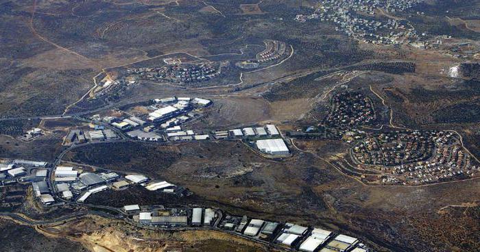
Territorial zones RF are areas that are united by the possibility of building certain objects. Within their limits, there are regimes of permitted use established by legislative and other regulatory acts. The territorial zones of settlements in which a large number of people live are called multifunctional. They house warehouse, industrial facilities, public and business buildings and engineering infrastructure.
Classification
It is carried out depending on the purpose. So, territorial zones are distinguished:
- Residential development.
- production.
- Public and business purpose.
- Transport and engineering infrastructure.
- Recreation.
- Agricultural use.
- Special Purpose.
- To accommodate military installations.
Each category on the master plans and diagrams has its own designation. In addition to the above list, other types of territorial zones can be established depending on local conditions. The designation of the same type of areas within each of them may vary. The composition of the territorial zones may include streets, roads, embankments, passages, boulevards, squares, reservoirs and other objects. Within their limits, there may also be areas where special urban planning regulations and restrictions on use apply.
Residential development
Such territorial zones are used to accommodate structures of various heights. There may be multi-family or individual houses. Territorial zones of land under residential development may include free-standing objects of cultural and social services for citizens, religious buildings, parking lots for vehicles, utilities, storage, industrial facilities, the operation of which does not adversely affect the environment. 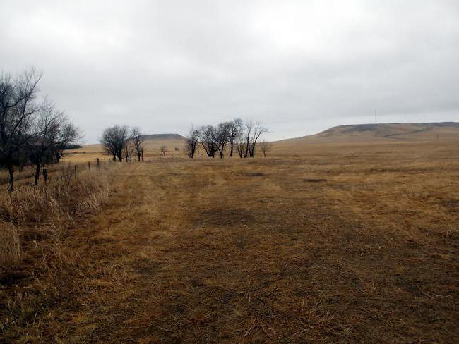
Notation
The territorial zone of a land plot intended for residential construction can be identified on master plans and diagrams as follows:
- Collective gardening - G1.
- Low-rise buildings of a cottage type, blocked or detached individual houses - Zh2.
- Mixed low-rise buildings - Zh3.
- Mid-rise buildings - Zh4.
- Buildings with 9 or more floors - Zh5.
ODZ
Public and business territorial zones are used to place objects:
Residential buildings, hotels, multi-storey or underground garages can be located within the ODZ. In the general plans, the territorial zone of the land plot for the placement of public and business facilities has the following designations:
- D - all the above types of development with the inclusion of residential buildings, engineering infrastructure associated with their maintenance.
- D1 - multifunctional complexes.
- D2 - objects of health care, secondary and higher vocational education, culture, administrative and research centers, places of worship.
- D3 - multifunctional public and business development in the newly formed territories.
- CI - all types of objects listed in the list, including water transport facilities, residential buildings and infrastructure serving them.
- Railway - public and business building with the placement of housing estates.
Location of production
Industrial territorial zones are used to accommodate storage and utility, transport and infrastructure facilities that ensure the functioning of enterprises. Owners of production facilities carry out landscaping at their own expense. In industrial areas, sanitary protection zones are established. They do not allow placement of preschool and educational institutions, residential buildings, healthcare facilities, sports and recreation, sports complexes, horticultural, dacha, horticultural cooperatives and enterprises producing agricultural products. On the general plans, industrial territorial zones are indicated:
Additional categories
Production zones include subzones:
- P1. Industrial enterprises of the 1st class of hazard are located here. In these territories, the development of related and auxiliary industries, organizations of a lower level of danger is allowed.
- P2. Within this subzone, enterprises of the II class of hazard are located.
- P3. Organizations belonging to the III class of danger are located here.
- P4. Within the boundaries of this subzone, enterprises of the IV class are located. harmfulness.
- P5. On this territory there are organizations of the V class of danger, including those that do not have sanitary protection zones.
- P6. In this territory there are facilities for communal and warehouse purposes. These include goods stations, trading / vegetable bases and other objects.
Within the zones P3-P6, it is allowed to place organizations whose work relates to the created or ongoing production activities. Business establishments usually form the SPZ sector between the sources of industrial emissions and the beginning of the residential area. The areas of sanitary protection zones for enterprises of classes I-II can be changed in accordance with the decision of the Chief Sanitary Doctor of Russia or his deputy, for production of III-V classes. - by order of the head physician of the subject or a person authorized by him. 
Transport and engineering infrastructure
These territorial zones are used for the placement and operation of facilities and communications for automobile, rail, sea, river, pipeline, air transport and communications, as well as service equipment. A prerequisite for the location of objects is the observance of certain distances between them and housing estates, recreational and public and business complexes, as well as other requirements aimed at preventing a negative impact on the environment. If the objects act as sources of danger or harmful effects on the health of citizens, they are transferred outside the boundaries of the territorial zones of residential development. Landscaping of areas intended for the placement of transport and engineering infrastructure facilities is carried out by their owners. The responsibilities of the subjects also include the creation of sanitary protection zones.
recreational facilities
They are located in their respective areas. Within their boundaries are gardens, parks, urban forests, beaches and other facilities used for recreation of citizens. Recreational zones may also include valuable and specially protected natural complexes. Within their boundaries, the construction and expansion of functioning storage, utility and production facilities is prohibited. Exceptions are facilities used to ensure the operation of health and recreational complexes. On the master plan, such zones can be indicated:
Agricultural areas
Within the boundaries of the city and the countryside, arable lands, vineyards, orchards, pastures, vegetable gardens, as well as territories occupied by agricultural buildings, structures, and buildings are distinguished. Agricultural activities can be carried out on these areas until the category of their use is changed in accordance with the development rules and the general plan. Zones can have the following designations:
- C - agricultural land, greenhouses, nurseries, production facilities for agricultural purposes. Engineering and social infrastructure can also be located here.
- C1 - greenhouses, nurseries, agricultural land.
- C2 - production facilities for agricultural purposes, including engineering communications, social infrastructure.
- C3 - dacha farming and gardening.
water areas
International legal acts define such a concept as a zone of territorial waters. The key provisions governing the water area are established in the 1958 UN Convention. In accordance with the document, a distance of 12 miles (22.2 km) is allocated, counted from the maximum low tide line - the territorial sea - the adjacent zone to the continental part of the state. In Russia, its width is set at 12 miles. About 30 countries adhere to the previously existing limit of 3 miles. The entire area of the territorial sea, its subsoil and bottom, and the airspace above it belong to the coastal state. At the same time, according to the Convention, the right of peaceful passage of foreign ships in this water area is recognized. This provision is a compromise solution to the issue of state sovereignty and the interests of international navigation. The passage will be considered peaceful if the security and good order of the coastal country is not violated. The movement of ships of foreign states must be carried out continuously and quickly. When passing, ships are required to comply with the rules of the coastal country, established in accordance with international regulations. 
ZTR
The Russian Federation provides for zones of territorial development, the formation of which is regulated by federal legislation. The definition of ZTR is established in paragraph 1 of Art. 2 FZ No. 392. It is part of the territory of the region of the country, where residents are provided with state support measures. ZTR are formed to accelerate the development of the respective region in social and economic terms. Creation favorable conditions aimed at attracting investment. Territorial economic zones are formed within one MO. It is allowed to create ZTR in several municipalities, if they act as urban districts or administrative regions. At the same time, MOs can border on each other, but must be located in the same region. ZTR lines are determined by the limits municipalities on which they are located.
Functional zoning
It is carried out to ensure the rational formation of the spatial and planning structure of the area. The establishment of functional zones largely helps to prevent the negative impact of production factors existing on the territory on the health of the population. There are the following categories of terrain:
- Residential. It is designed to accommodate residential areas, green spaces, community centers.
- Industrial. Manufacturing plants are located within it.
- Communal warehouse. It is intended for depots, garages, cargo storage areas and other facilities of a similar purpose.
- Recreational. There are parks, beaches and other places for short-term recreation of citizens.
Also, within the limits of the settlement, an external transport zone is provided for freight and passenger stations, marinas, and so on. In addition, within the city limits, areas outside the development area are envisaged. There are tree nurseries, subsidiary farms, cemeteries, as well as reserve plots that are temporarily used for various purposes. All areas that belong to the city are limited to the boundaries of the settlement.
Suburb
In large settlements in the territories adjacent to them, a special zone is formed. The suburb is necessary to ensure the further development of the city. Mostly commercial services are located here. The suburb can influence the microclimate of the settlement. Fruit and vegetable bases, farms and other agricultural facilities that provide citizens with food can be located on its territory. The suburb is also a place of recreation. Children's camps, dachas, sanatoriums, boarding houses are often located here. In addition, communal facilities and processing enterprises are located in the suburbs. In all suburban areas there is a forest park belt. In accordance with the profile of the city, other areas can be allocated in the structure. For example, in the settlements of a scientific orientation, a zone of research institutes, universities, and design bureaus is provided. Residential and industrial areas are allocated in large urban settlements. In the latter, in fact, communal storage and industrial zones are combined. Proper site planning is essential. All zones should be located taking into account the territorial development, the need and possibility of creating a SPZ and gaps between housing estates and industrial facilities.