Through the creation cadastral service, today everyone has the opportunity to search in the public domain for any information about land plot.
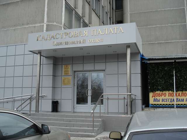
Direction of activity of the cadastral chamber
The activities of the cadastral service are defined by law and consist in registering and establishing the number of a land plot with the formation of all the necessary documents for this.
All materials are collected and processed by a special manager - a cadastral engineer.
Eventually:
- the specialist collects the documents submitted by the consumer (specified in the legislation);
- processes;
- registers and assigns a number to the land plot.
Everyone who is a cadastral engineer has a personal certificate confirming his qualifications. In addition, an employee of the cadastral chamber must have a unique enhanced electronic signature.
The cadastral engineer deals with:
- individual entrepreneurs;
- An individual.
All data provided in cadastral chamber must be genuine, otherwise there are precedents for the cancellation and annulment of the cadastral certificate for land.
Such cases include:
- Detection of forgery or fraud in documents;
- If the cadastral engineer is deprived of the right to conduct activities, by a legal decision of the court;
- The cadastral engineer personally submits an application for the annulment of one or another certificate issued by him;
- Errors or inaccuracies in cadastral document approved by a specialist engineer;
- Documents not submitted by the cadastral engineer to the accounting service on time (regulated period - 30 days).
Interaction of citizens with the cadastral chamber
For citizens, the creation of such a service is a big step forward in terms of land plots and execution of all relevant documents.
For convenience, an open map of the cadastral system was created, which is publicly available online on the official resource.
It is through the conduct modern technologies full-fledged close interaction with citizens is ensured.
Although, it is worth noting that it is possible to obtain data on land issues, register a plot in the traditional way, by means of a personal appeal to the cadastral engineer with an official application.
Terms and cost of cadastral services
Based on the regulations in the current legislation, the deadlines for processing the submitted documentation are established. For the settlement of cadastral plans, no more than 5 working days are allotted from the moment they are submitted.
But, at the same time, the deadline for submitting documents to a special service is 15 days, upon request. In order not to have to queue up again, it is necessary to check the authenticity of all documents in advance and eliminate possible errors and inaccuracies.
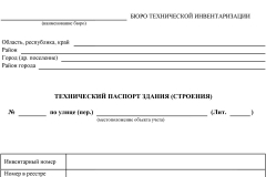
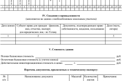
In order to obtain a cadastral certificate for land, you must provide a complete package of documents:
- A document confirming the entry of property in the state register;
- Statement of the property;
- Territory plan;
- Statement of the total cost of the site;
- Property passport.
At the same time, it is worth knowing that when applying there is no need to provide original documents, it is quite possible to get by with certified copies.
Providing a response to the submitted request can be provided, both in writing and electronically, at the request of the client.
According to the instructions given in the orders and legislative acts a fixed cost of payment for the services provided by the cadastral chamber for the inclusion of a plot in the State Property Committee has been established.
Depending on the type of response (paper or written), as well as whether the application was filed by an individual or legal entity the cost can vary from 800 rubles to 2400 rubles.
The electronic version is much cheaper: from 200 rubles to 350 rubles.
Why register the right to real estate?
In general, we can say that the cadastral chamber operates in two main areas:
- Authentication state registration land, absence of inaccuracies or fraud, inconsistencies or errors.
- Sending a response to the application for the existence of the site, its series, numbers, both in writing and in electronic form.
Registration of a land plot in the state cadastral chamber makes it possible to significantly increase the rights to property, real estate.
In addition, the possibility of corruption and illegal operations with land is completely excluded.
Features of cadastral registration
The peculiarities of the cadastral certificate include the fact that it can be considered invalid not only if the applicant submitted false data, but also errors and inaccuracies on the part of the cadastral inspector.
If necessary, the engineer may personally submit a request for the annulment of his decision to issue a passport.
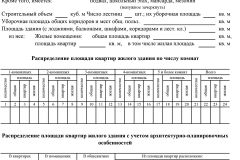
Cadastral services prepare documents confirming the land surveying plans for the site, and also establish an act of surveying the site.
The location, boundaries and erected structures will be determined, and the facts of construction in progress will be entered as notes.
Also, the cadastral engineer is obliged to submit a request, at the end of the period for processing documents, for the issuance of a special notice by a special supervisory authority.
Also, such a request must be fulfilled if there have been changes in the full name, place of residence, contact details and all the characteristics specified initially.
How to get information from the state real estate cadastre?
Having a cadastral number in hand, you can use a special service on the Internet and find out information about a land plot, find a state act.
Provided that the number was issued in a public chamber before 2004, it is necessary to apply for help to assignment certificates. In the absence of any data, the site does not pass proper registration.
If there is a number, you can enter it in the search feed on official portal and press the search button.
If information is found, it will be displayed on the screen:
- Cadastral number;
- Destination code;
- Footage, plan and location;
- Type of ownership.
At the same time, it is necessary to clearly understand that the data about the owner is not issued in the public domain, they will not be displayed.
But you need to understand that the site may have some errors or inaccuracies associated with inaccurately submitted data or past changes:
- The site may not be found on the map (for whatever reason);
- The cadastral number will not be found;
- The boundaries of the site will be aligned with another, cross lakes or rivers;
- Part of the site may face the road;
- Errors or inaccuracies in the location address.
If an error, inaccuracy, or any graphical interference is found, it is recommended to immediately send a comment to the cadastral chamber, by means of feedback.
But at the same time, it should be understood that this is a computer system that can malfunction.
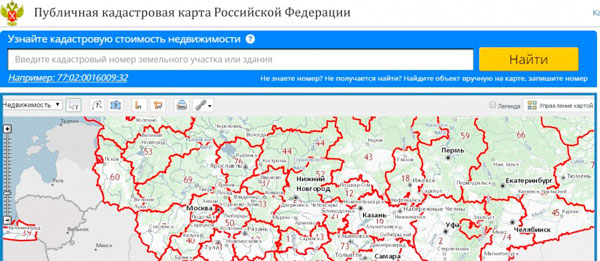
Are you interested in what is a cadastral public map of land plots of the Russian Federation?
What is this site, how to use it and what information can you find out who has access to the resource? Consider the latest information on this topic in 2017.
Have you heard about such a concept as a cadastral map, but wondered - what do they mean by this term? Let's figure out what it is, by whom and for what it can be used.
Basic moments
The cadastral map is quite easy to use. With its help, you can find the necessary object in a matter of seconds and find out its number.
Every professional, even before concluding a purchase and sale agreement, etc., looks at a similar card to clarify the cost in order to know about the possible amount of tax payment.
Cadastral map - an opportunity to simplify the work for a realtor, cadastral engineer, owner, surveyor, builder, appraiser of immovable objects.
What it is
A public cadastral map is an information site where you can view data from state cadastre land on immovable objects of each subject of Russia.
The public map was developed to facilitate the work of employees in various industries. Since 2010 this information- open material that is available to everyone.
Why is she needed
With the help of a cadastral map, you can obtain the necessary information for transactions with immovable objects, land plots - for sale,.
The cadastral characteristic will affect the amount of tax payment that is made when buying and selling, renting.
Every citizen of the Russian Federation can use such a card:
- get data about the lands;
- find real estate;
- find the unit of cadastral division;
- find out the cadastral number;
- find out the address of the property;
- see what is the area of the object;
- find out which branch of Rosreestr operates in the region;
- prepare for land surveying.
Data from Rosreestr, which will be provided:
- land address;
- status;
- object price;
- form of ownership;
- the number when the object is put on the cadastral type of accounting;
- a number of characteristics of objects.
You will receive an extract from the State Cadastre, a certificate of the cadastral price, cadastral passports, plans of the territories.
![]()
Viewing Features
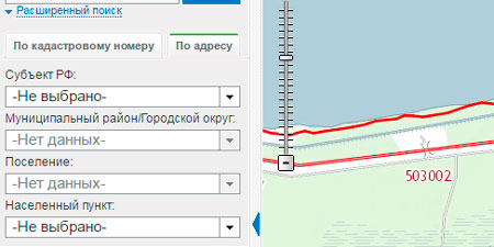
In order to get acquainted with the information of the State Committee for Customs Control online, you should go to the site that was developed by the state cartography authority.
The following information will be covered:
Sometimes cadastral plots indicate the location of the street. 
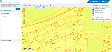
The cadastral map has the following legal status:
- the first declaration of the Council of OSM, RF on address data;
- PKK Rosreestr;
- conclusions of the data of the Freedom Foundation about the problems in the use of cartography data.
Official website of the public cadastral map of land plots
 The public map can be viewed through any browser. All that is required is to enter the data into the search engine and in a few seconds the system will return the result.
The territory can be viewed on images taken from the satellite, or in topographical versions.
User Guide
Rules of management:
It is possible to change the cartographic basis. On a base basis:
- include a card without a base by selecting "no";
- look at the map of the Russian Federation provided by Rosreestr;
- look at a map with orthophoto coverage;
- satellite images of the area will be presented;
- You will see the name of the geographic feature by clicking on "Map Labels".
![]()
When choosing a thematic map (click "map management"):
- clicking "no", you will see the usual base map without base;
- using large scale choose an object and look at its cadastral value;
- learn the type of permitted uses of certain land plots, categories;
- find out how relevant the information that is entered on the card;
- find out the number of views of districts.
 Additional Information:
- land boundaries;
- the border of the region;
- cartogram;
- zone with special conditions;
- boundaries of the territorial zone;

- the overview map is used to select a new tool without closing the current images. When the function is selected, expand the map to full screen.
- to view the style in the design of each object, click "Legend".
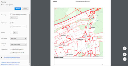
- to print a fragment of an image, click the appropriate button. Select the zone to be printed, and then click on the icon. You can make an inscription. Date setting is automatic.
- to measure the distance, find the corresponding icon among the tools.
 It is possible to draw lines on the map and measure distances along them. Lines can be moved, added.
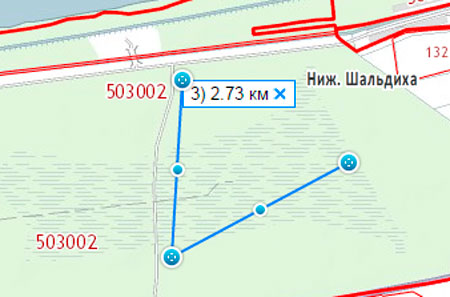
- to measure an area, find the icon and use the same procedure.

- click on the icon to get the link that was opened. Bookmark it or email it.
- object can be added.
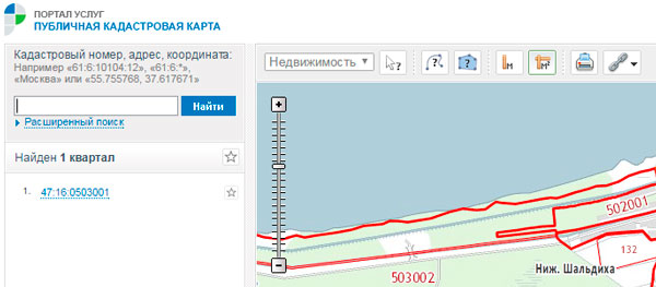
To find an object on the map, certain parameters are taken into account. In the quick search bar at the top there is a line where you enter information about.
The system will automatically select objects. The panel can be collapsed or expanded, it is possible to adjust the number of results that will be displayed on the window page.
When searching:
- enter data in accordance with the cadastral passport, certificate. The number will be like this:
AA:AA:AAAAAAAA:AAAA
- indicate the address.
- represent the coordinates of a point.
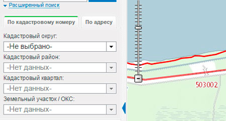
 With advanced search, you can search by:
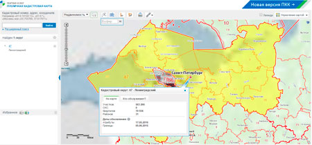
 The result will look like this:
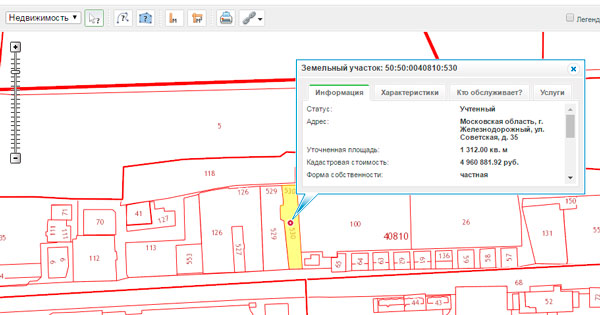
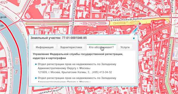
When you hover over an object, all the information that the cadastral service contains will be displayed.
To save data:
- it is worth adding the result to "Favorites";
- you need to click the button to download or upload the data in csv format.
For more information on the object, you should go to the state cadastre department.
What is the cadastral number for?
Many are interested in what is the cadastral number of land plots on public map Russia.
Video: how to find a free land plot on a cadastral map
When placing an object on cadastral registration, it is mandatory to assign a cadastral number. Finding out what number this is is not difficult - you can find it out at the state registration authority.
Cadastral numbers have 4 groups of numbers that identify the land:
- District - 2 digits.
- District - 2 digits.
- Quarter.
- Plot number.
After the reforms, all plots were assigned a number, which is entered in the passport for the land plot.


The cadastral number is a coded numerical designation of the address of the land. In the presence of such an element, we can say that the object is legalized and has the official status of real estate.
When such a number is assigned, the land can be involved in a number of transactions.
This number is assigned only once. It is not changed when ownership is transferred or the form of law changes.
The number will go out of circulation if the land plot ceases to exist - it will be divided, withdrawn or redeemed.
Cadastral numbers are unique and cannot be transferred when registering other plots. The number is tied to a number of characteristics - they are obtained by numbers, verified and changed.
You can find out from it:
- technical information about the site;
- square;
- addresses;
- data on completed transactions;
- borders with adjacent areas.
Sometimes they find out that the cadastral number is missing. This may be when:
What are the advantages of satellite view
The public cadastral map with a satellite photo is an all-Russian resource. It is presented in the form huge photo RF that was mounted from many small photos.
Such pictures were taken from space by the Esri or Scanex project. Advantages - there is open free access to cadastral data.
Any user can use the online system. The map is a unique tool with which you can find out where the object is located, with which areas it neighbors.
How much does it cost
To find information about the land, the user does not have to pay anything. When will you need to spend?
The cartographic basis of the earth's surface is transferred to an electronic or paper carrier of satellite communications.
It is recorded by an accurate device with a minimum error. They are used for the multidisciplinary needs of different authorities and departments.
It may be necessary to make a copy of the map from the owner of the site. In accordance with, the data of cadastral passports and plans are interconnected.
The passport reflects information that is taken from the topographic indicator of the plan. Both documents must contain the same information.
Plan may be needed when lost cadastral passport, the old cadastral number changes, the land plot is registered, etc.
Receipt cadastral plan impossible (only its copies in the form of extracts). A document of this type is issued at the MFC at the location of the object.
The amount of state duty for the provision of services by a representative of the authorized body is 200 rubles if the land is registered, 350 if not.


To find out information about a land plot or find real estate in the capital, you should refer to the public cadastral map of Moscow land plots for 2017.
Similarly, you can find information about objects in other regions.
The map will show the number of allotment, address and other information. Such data is simply necessary when making and renting.
When using the card, you will be able to solve a number of issues - about putting the property on the cadastral register, about taking into account changes in the object, about the assessment.
The cadastral map is a repository of valuable information that becomes available from tablets and smartphones.
Now there will be no need to stand in a huge queue to find out the data on the land plot.