
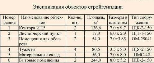
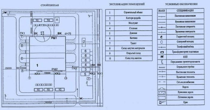
The plan of the site, where the exact location of all objects under construction, the arrangement of lifting and mounting mechanisms, as well as many other economic objects, is located, is a construction general plan. Warehouses are displayed building structures and materials, mortar and concrete units, temporary premises for cultural, sanitary, hygienic and administrative purposes, communication networks, power supply, water supply, etc.
Types
The area covered and the level of detail affect the type to which the building master plan belongs. It can be object or general site. For the largest construction projects, including water management, the construction master plan is not limited to these types, a situational plan is necessarily drawn up, which characterizes the conditions of the area in relation to the construction industry.
The situational plan indicates not only the location of the construction, but also the construction industry enterprises existing at the facility:
- quarries where sand and gravel are mined;
- factories where they come from reinforced concrete structures, brick and metal structures;
- all means of communication: water, rail, road, power lines and much more.
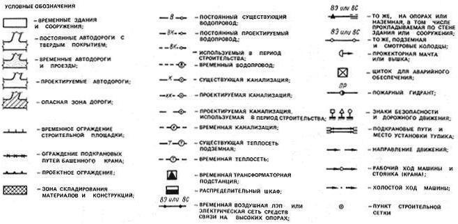
The construction master plan for drainage and irrigation systems additionally has designations for the boundaries and areas of drained and irrigated territories. Also, the plan should indicate the sequence of commissioning of each node and the boundaries of operational and construction sites, the boundaries of water drainage and flooding of territories, all bridges and

Planning
The development of a construction master plan begins with a list of objects economic activity, which are to be used to the maximum in construction. These are energy supply enterprises, the construction industry, various buildings for construction needs, and so on. If there are no such facilities or their capacity is insufficient, then temporary structures of a similar purpose are designed. The development of a construction master plan of a general site type covers the entire territory of the construction site and includes absolutely all of its facilities.
The plan consists of graphics and an explanatory note with the rationale for each decision of the graphic part, which includes a detailed plan of the construction site, the operation of permanent and temporary facilities, conventions, as well as fragments of the plan with technological schemes. In addition, in the graphic part, the design of the construction master plan assumes the presence of technical and economic indicators and notes. General site scale building plan can be 1:5000, 1:2000 or 1:1000.
Sequence
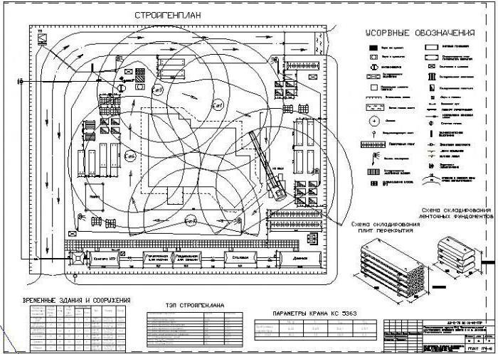
The master plan for a construction site usually begins with the placement of roads for internal construction vehicles, at the same time the location of mechanized installations and general site warehouses is planned. Only after that it is possible to place all the main construction and economic objects. After the completion of this work, the projected temporary networks of power supply, water supply, and heat supply are included in the master plan of the construction site.
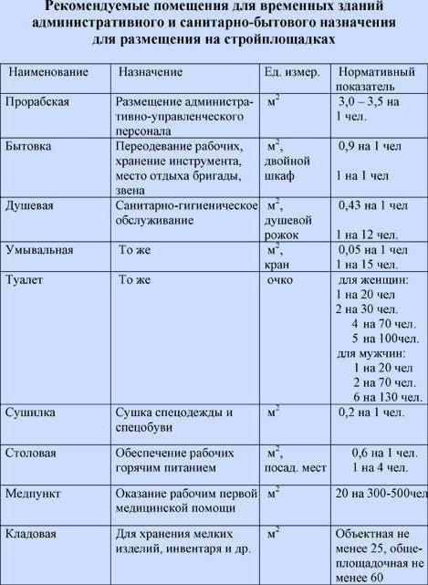
When performing all this design work, one must be guided by the results of calculating the needs for these objects, as well as special rules for placing them. For example, the calculation of the construction master plan should take into account that the distance from food points to household premises should not exceed six hundred meters (here you need to focus on the rules), to household and sanitary facilities should not be more than two hundred meters, and to production work no less than fifty meters. Also on existing rules fire breaks are planned between the premises and between the warehouses.
Design stages
The construction master plans necessarily include calculations of the needs for certain resources, as well as for construction and utility facilities. All this is given in the explanatory note. In a general site building master plan, this information is usually given approximately, based on standards.
During the construction of water management and hydraulic facilities, it is necessary to show all devices and structures that provide construction water consumption during the construction period, as well as a breakdown of the order of all work on the construction of a complex or a unit of hydraulic structures.
There is a one-stage design, which is usually associated with medium-sized construction projects, then a general site construction master plan is not drawn up. The types of construction plans are basically listed, it remains to specifically talk about the second of the main ones.
Object construction master plan
It is being developed, as already mentioned, especially for each object from those shown in the general site plan. Also, an object construction plan can be drawn up for each of the stages of work: the preparatory period, the zero cycle, the construction of the above-ground part. Its graphic part contains the same elements as in the general area, only each issue is worked out in much more detail.
Scaling is mostly the same. Construction and utility facilities are placed in the same way as when designing a general site plan, necessarily in accordance with the established rules and accepted calculations. The only difference is that there can no longer be approximate calculations, since there is a basis for the natural volume of work, resource consumption rates, and so on.
Compilation procedure
The design of an object general plan begins most often with the choice of assembly and machines and their specific and rational placement. Then it will be clear how to establish places for storing building materials, prefabricated structures, where to place internal roads. After the end of these design work other construction elements are also placed according to the list (SNiP 3.01.01.85).
When various buildings or structures are erected, not only these objects under construction, but also numerous temporary auxiliary buildings, which are necessary for the needs of the construction site, the so-called construction industry. For construction transport, tracks and roads, conveniently located administrative and industrial buildings, various mechanized installations, warehouses, networks of technological pipelines, water supply, and power supply networks are equipped.
purpose
The construction master plan exists in order to provide the construction site with all possible necessary conditions- household and industrial, so that acceptance, storage, delivery for each workplace necessary building materials, semi-finished products and products.
It is necessary that all construction mechanisms and machines work normally, so that the construction site is supplied with heat, water and electricity without interruption. The construction master plan reflects all solutions to the issues of construction safety, labor protection, fire prevention measures, as well as lighting the entire construction site at night.
Temporary buildings
At the construction site, among the permanent facilities under construction, a special place is occupied by buildings that are used only during the construction period. Their construction is designed in the first place, and after construction is completed, they will be dismantled or demolished. Also, railways and roads located on the construction site are considered temporary structures.
For example, rails for tower cranes will definitely be removed when they are no longer needed. All warehouses for materials and products, as well as outdoor lighting, fire hydrants, construction site fences - all this will be removed after construction is completed.
Differences in master plans
Judging by the composition, construction master plans differ from each other at each stage of work, which is characterized by the completeness of the nomenclature, the degree of detail and the exact location of all temporary and permanent structures.
During development, special attention is paid to rational use construction area, minimizing the cost of temporary structures and buildings, rational placement on the construction site of everything necessary for the operation of the economy. Environmental issues are also very important.
Initial data
For the design of building master plans, the most important are the following: dimensions, location and nature of the construction site, size and topography of the territory, characteristics of materials, structures and parts used in construction, types of mechanization to be used, and methods of installation of structures. Required calendar plan construction of a given facility or a network schedule.
A lot depends on the relief of the construction site: the placement of temporary and permanent facilities, the optimal directions of iron and highways, drainage of sewage and storm water from the construction site. The climatological input data should be consistent with the choice of the type of premises for storage (they can be closed or open), as well as the places where they should be located. For example, open warehouses with dusty or flammable materials are equipped with
Stages
The design of a building master plan usually contains three stages. First, the composition of all temporary structures is determined, then the locations of all construction elements are outlined, and finally, accurate calculations are performed.
When a construction master plan is being designed, it must be correlated with the general plan, where engineering networks that already exist are indicated, because temporary structures cannot be located at the site of laid communications. This is also what makes it possible to use permanent networks for construction needs.
Roads, warehouses
Roads inside the construction site are located so that it is convenient for the passage and exit of vehicles, as well as loading and unloading. Road network necessarily provides for a ring road. The width of the roadbed of temporary roads is determined taking into account the transport that will be involved. Most often, temporary roads are built from reinforced concrete inventory slabs laid in two rows.
Warehousing is organized according to the draft construction plan. Warehouses can be:
- heated and not;
- enclosed spaces;
- in the form of open or under canopies of platforms.
Capacity is designed depending on the amount of materials and their storage conditions. Warehouses at the construction site are divided into on-site and general site. The latter are of a closed type, designed for expensive and perishable materials (glass, paint, fittings, etc.).
Master plan of the city
The master plan of the city is developed on the basis of the national economic development plan of the country and is a scientifically based long-term plan for the development of the city. After that, the master plan of the city becomes the main urban planning document, on the basis of which all specific projects for the planning and development of the city are drawn up. It determines the development prospects, the general planning structure, the nature of the development, the system transport service, the direction of measures for the engineering preparation of urban areas, planning, improvement and gardening. In general; The plan indicates the sequence of construction based on the convenience of life in the city.
One of the most illustrative examples of urban planning is the General Plan for the Development and Reconstruction of Moscow. The year 1961 is considered to be the starting point, when preparations began for the design of the master plan and the implementation of its first phase. At present, all town-planning transformations are already being carried out within the framework of the second stage.
The master plan of the city includes a graphic part and; explanatory note. In the graphical part, in a generalized form, at the level of the technical project, the planning of new, reconstruction of existing areas, vertical planning and engineering preparation of territories, laying of underground utilities, organization of surface water drainage, landscaping, transport system, lighting scheme are presented.
The explanatory note describes decisions taken, feasibility studies and calculations.
The materials of the general plan of the city are fundamental for further detailed study of design solutions at the level of working drawings, according to which construction and reconstruction are carried out. The general plan of the city contains the main idea that satisfies the pressing problems of society in the near future.
Design of new and reconstruction of existing urban and rural settlements carried out according to SNiP 2.07.01-89 * taking into account MDS-30-1.99 " Guidelines for the development of zoning schemes for city territories”, GOST 21.508–93, SPDS “Rules for the implementation working documentation master plans for enterprises, structures and residential urban facilities” and GOST 21.108-78.
When designing new or reconstructing existing ones within urban and rural areas, microdistricts, complexes and buildings, the first design document includes a master plan (general plan) of the facility.
The master plan contains information about all aspects planning solutions on the territory allotted for construction or reconstruction:
On the location and orientation of the designed and existing buildings and structures (layout plan);
Designed driveways, sites, their purpose, system walking paths, landscape design species of trees, shrubs, lawn grasses and flower plants used for landscaping (landscaping plan);
Small architectural forms ah, vertical planning devices and their planar dimensions (territory improvement plan).
On the master plan, vertical and horizontal references of the designed objects to existing buildings or to the boundaries of the plots allocated for development are performed. On the basis of the general plan, a plan for organizing the terrain is drawn up, which includes a vertical layout, an excavation plan, and a master plan for engineering networks.
According to preliminary studies of the existing state of the site intended for construction, they are geo-base, which contains information about the terrain, existing underground and surface communications, roads, sites, structures, green spaces. Drawings of master plans are carried out in strictly defined scales: 1:500, 1:1000, 1:2000. The master plan contains information about the designed object in its final form. It depicts objects in the dimensions that they occupy at ground level along the outer perimeter of the walls. Around the buildings have a blind area 3 mm wide, regardless of scale. The orientation of buildings is fixed with the help of a wind rose, which is placed in the upper right corner of the drawing with the obligatory indication of the direction arrow to the north.
The master plan shows a design solution for the improvement of the territory, carried out to increase the efficiency of its use, improve appearance and ecological state, protection environment and taking into account the functional provision of the social conditions of its operation.
The designed driveways must be connected to the existing transport network of the city, village or country roads. Driveways lead to each entrance or to the main entrances to buildings. Near the entrances, free areas are designed, the area of \u200b\u200bwhich depends on the purpose of the buildings according to the standards. At the entrances of residential buildings, free passages are organized for the movement of residents, the introduction of furniture. Near the entrances to public buildings (cinemas, exhibitions, schools, state institutions) design free areas for waiting, meetings, movement of large flows of people.
Streets and driveways are located no closer than 6 m to buildings. The radii of turns of streets and driveways are determined from the conditions of traffic safety, unhindered passage of fire trucks, visibility for drivers and pedestrians. Sidewalks are designed along streets and driveways longer than 100 m. The free territory is functionally zoned and used for the location of playgrounds and footpaths. The sites are located according to their purpose in quiet, active or economic zones. They are trying to isolate them territorially. Streets, driveways, sidewalks and platforms - flat structures - are delimited by side and curb stones, which are shown on the general plan as single lines.
For all planar structures, continuous dimension lines are drawn in two directions. They are tied in size to the boundaries of the site, the carriageway of streets or to the axes of buildings. For the designed buildings, the extreme axes are shown and designated. According to them, the designed buildings are tied in two mutually perpendicular directions to existing buildings or to the boundaries of the site (horizontal snap).
The existing terrain is indicated by black contour lines that do not pass through the designed buildings and planar structures. For the designed buildings, vertical anchor to the terrain. The result of the vertical binding is fixed on the drawing in the form of a record of marks on special shelves placed at the corners of buildings and in the middle of each designed building in a rectangle. In accordance with the identified black marks of the unchanged relief of the site or the design marks of the variable relief along the sides of the building, arrows show the direction of surface water runoff.
Landscaping is designed based on the purpose of the object. Existing green spaces are retained only if they are in good condition and have a reasonable location. All designed trees and shrubs on the master plan have their own symbols and planting sites, tied in size to the boundaries of green areas, indicating species, number, age.
The constituent elements of the master plan are indicated by the color of the hillshade, shading, numbers. In order to read the drawing in detail together with the general plan, symbols are applied, the explication of buildings and structures, the balance of the territory, the nodes of sections for landscaping and coatings.
The explanatory note includes the section "Description of the General Plan". It details the specific solution to all of the above problems with numerical data. In conclusion, the technical and economic indicators of the general plan are given: building area (ha), asphalt pavement area (m 2), tiled paving area (m 2), landscaping area (m 2), as well as building density, population density "net" and " gross" for large objects.
The master plan of engineering networks shows the laying of all existing and planned permanent underground communications. Their location is taken into account when designing a vertical layout, small architectural forms and landscaping, the state of which underground networks can have a harmful effect on.
The construction of the object begins only after the approval of the project, which before that is subjected to an independent comprehensive (economic, technical, environmental) examination.
The master plan is a plan showing the design position of a complex of buildings, buildings, communications and other structures. Master plans come in different scales depending on the object presented on the master plan. The main regulatory document of the master plan is Urban planning code. Technical part the general plan includes SNiP 2.07.01-89 Urban planning. Data regulations operate throughout the Russian Federation.
The development of a project for the construction of a new building requires a competent master plan. It is necessary for the qualitative formation of a comfortable living environment and the maximum effective use adjacent area of the facility. This is a whole range of works on planning communication networks, transport and service infrastructure, landscaping and landscaping of the construction site. Not a single construction is complete without a competent development of a general plan, this is the most important part of the entire process of designing an object, which helps to optimize the implementation costs in the best possible way, as well as avoid unforeseen expenses. With it, you can calculate the entire budget of the project in detail.
The master plan is also necessary to demonstrate the economic attractiveness of the object to potential investors. Master plan documentation makes it possible to make all necessary calculations (administrative and commercial expenses) that will arise during the subsequent operation, which will greatly facilitate the further development of the project.
Our land management company is ready to offer you its services in the development of a master plan of any complexity. Specialists of CadGeoTrest LLC guarantee each client high-quality performance of work in the required time at a high professional level! We are ready to offer customers the best cost of work with the greatest possible attention to detail. Each of our projects in all respects complies with the standards of documentation systems for construction (GOST, SNiP, etc.).
Currently the most actual question This is a low rise building. Solving the state program for the provision of housing for young families, the development of lands located next to settlements. In order to ensure that cottage settlements are not of the same type and in order to improve their competitiveness in the suburban real estate sales market, a concept of the future settlement is being developed. In the future, it forms the basis of the master plan - a set of all required schemes, projects and drawings, made in compliance with all norms and rules, which are the main construction document.
At the concept development stage, issues are resolved with the project owners, administrative resources of local government on the placement, in a particular territory, of a cottage village and represents approximate schemes and models of where and how houses, kindergartens, schools, supermarkets and other buildings will be located. It is made on the basis of topographic survey, geology, and geo-base. All these data must be provided by the investor who is directly interested in this construction and, together with the contractor, develops and approves the terms of reference (TOR).
The approved concept with the TOR forms the basis of the general plan, which is one of the main permits, without deviating from it, the marking and construction of the entire village is being carried out. The development and design of the master plan is a very thorough and painstaking work, which includes the precise marking of each house and building, the allocation of land for roads, communications, engineering networks, lawns and sidewalks, and so on. This plan is the starting point for the design of the village. According to it, it becomes possible to calculate in detail the costs necessary for the construction of houses, engineering networks, roads and the rest of the infrastructure. Having received the master plan, investors can already calculate the real costs. The master plan contains the following information:
- calculation of the main parameters of the village, namely: the approximate number of people living in the future, the number of houses, their location relative to the cardinal points, the number of administrative buildings, engineering networks and the main parameters of construction projects;
- territorial division of the entire development zone, taking into account the norms of insolation;
- development of a network of roads and schemes of engineering communications, vertical planning of the entire territory;
- detailed planning of each object located on the territory of the future village, up to flowerbeds and benches, their exact location.
- economic and technical calculation of design parameters.
Based on the above parameters reflected in the master plan, all subsequent design stages are carried out. If suddenly even the smallest mistake appears in the plan, then this can lead to big problems during construction, therefore, the coordination and approval of the master plan of the cottage settlement is carried out taking into account a thorough check of each figure and size.